sport.wikisort.org - Stadium
Mickleham is a village in south east England, between the towns of Dorking and Leatherhead in Surrey. The civil parish covers 7.31 square kilometres (1,810 acres) and includes the hamlet of Fredley.[2] The larger ecclesiastical parish includes the majority of the neighbouring village of Westhumble,[3] from which Mickleham is separated by the River Mole.
| Mickleham | |
|---|---|
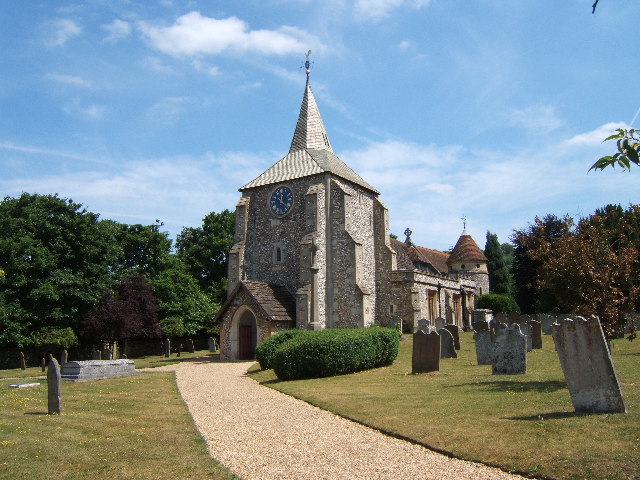 St Michael's church | |
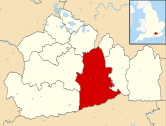
 Mickleham Location within Surrey | |
| Area | 7.31 km2 (2.82 sq mi) |
| Population | 585 (Civil Parish 2011)[1] |
| • Density | 80/km2 (210/sq mi) |
| OS grid reference | TQ171534 |
| Civil parish |
|
| District |
|
| Shire county |
|
| Region | |
| Country | England |
| Sovereign state | United Kingdom |
| Post town | Dorking |
| Postcode district | RH5 |
| Dialling code | 01372 or 01306 |
| Police | Surrey |
| Fire | Surrey |
| Ambulance | South East Coast |
| UK Parliament |
|
History
Mickleham lies near to the old Roman road known as Stane Street, which ran from London to Chichester. Then, acquiring its Old English based name, the small settlement lay within the Copthorne hundred the initial purposes of which were those of the feudal system — use for meetings of the wealthy and powerful for strategic purposes in Anglo-Saxon England and later becoming an area of land assessment for taxation.
Mickleham appears in the Domesday Book of 1086 as Michelham and Micleham. It was partly held by Nigel from the Bishop of Bayeux and partly by Oswald from (under) Richard de Tonbridge. Its domesday assets were: 7 hides; 1 church, 7 ploughs, 3 acres (12,000 m2) of meadow, woodland worth 4 hogs. It rendered £10 per year to its overlords.[4]
Nearby Mickleham Down was the venue for a single wicket cricket match in June 1730. The game was between two teams of three and played for a stake of £50. The teams, Surrey and Sussex, were described in a contemporary newspaper report as "esteemed the best in the respective counties" but it does not name the players.[5] This is the first and only reference to Mickleham in association with cricket of a senior level.
Mickleham is mentioned in Jane Austen's novel Emma (1815).
The philosopher and amateur botanist John Stuart Mill protested against the building of a railway though the "beautiful valley of Mickleham" in 1836.[6] The village has featured prominently in cycling, following the loops of Box Hill adopted by various versions of the London-Surrey Cycle Classic which has acquired a federation of European cycling points status as an annual event, since its use in the 2012 Summer Olympics.
Amenities
Places of worship

The main place of worship is St. Michael's Church, surrounded by St. Michael's Churchyard. The church (in full the "Parish Church of St. Michael and All Angels in Mickleham") has a Norman west tower and a Norman chancel arch, raised in the 1871 restoration by Ewan Christian, who added neo-Norman aisles and east end. The Norbury chapel on the north side is late Perpendicular, with chequerboard flint and clunch walling.[7] The majority of the stained glass windows are by Clayton and Bell with others by Percy Bacon Bros, Morris & Sons and a modern window by Alfred Fisher (2015).[8]
Community facilities and commerce
The village has two pubs (The Running Horses and The King William IV), a village shop (Rose's Stores) and an Italian Restaurant (Frascati).
The Mickleham Village Hall is on Dell Close and is available for hire.
Schools

In the village are Box Hill School, an independent secondary school, located close to the village shop, St Michael's Infant C of E (Aided) School and St Michael's Community Nursery.
Transport
- Roads
The A24 bypasses Mickleham with a dual-carriageway bypass.
- Railway
Box Hill & Westhumble station, located across the A24, and towards Westhumble, provides a link to London and Horsham.[3]
- Buses
The 465 bus route runs every hour or half-hour (except nights) between Kingston upon Thames and Dorking, via Mickleham village.[3]
Localities
Fredley
The hamlet and former manor of Fredley is approximately 300m south of the centre of Mickleham. Juniper Hall, run by the Field Studies Council is located there.
James Clavell, the Australian novelist and screenwriter, lived at Fredley Manor between 1970 and 1990.[9]
Mickleham Downs
The hillside to the east of the village, known as Mickleham Downs, was donated to the National Trust in January 1939 by Lord Beaverbrook, the proprietor of the Daily Express newspaper, who had recently purchased the Cherkley Court estate.[10][11]
Norbury Park
Across the Mole and the A24 is Norbury Park. In this is the 'Druids Grove' which is an area of mature Yew trees.
The Burford Bridge and the zig-zag road
Here is the hotel that was frequented by Lord Nelson, 150m north of which starts the Zig-Zag road, one of the two local roads for motor vehicles climbing Box Hill.
Landmarks
The surrounding area contains many Sites of Special Scientific Interest (SSSI) including the Mickleham Downs and panoramic beauty spot of Box Hill.
The River Mole flows nearby. As its name suggests, the river in places goes underground due to the chalk bed being dissolved, forming swallow holes (sinkholes). Ian Middleton tells of his father, sometime in the 1950s, the village police officer P.C. Middleton, looking past his bathroom mirror one morning whilst shaving to see a mature oak tree disappear into the ground. It turned out that the river flowing underground had been gradually wearing away the supporting ground under the tree, forming a giant such hole which had collapsed. The subsequent pit was not filled in until about 1968 approx when it was still 30 ft deep and 30 ft across. P.C. Middleton also reportedly removed parts from an unexploded V2 rocket which fell in the village during World War II.[citation needed]
Notable residents
- Richard Bedford Bennett, 1st Viscount Bennett, Prime Minister of Canada from 1930 to 1935, retired here after his life in politics. He is buried in St Michael's Churchyard, the only former Prime Minister of Canada not buried in that country.[12]
- Mrs. Maria Drummond lived at Fredley and was buried here.
- Sir Stuart Etherington (b. 1955), leading charity executive and former social worker, was brought up in the village.[13]
- Detective story writer Cyril Hare was born in Mickleham Hall in 1900 and died at Westhumble in the parish in 1958; he is buried in the churchyard. So is his wife's grandfather, Sir Trevor Lawrence, who had famous orchid houses at Burford Lodge in the parish.
- Sir John Norton-Griffiths, 1st Baronet, "Empire Jack", the driving force behind the Tunnelling companies of the Royal Engineers in WW I, was buried at Mickleham Church on 18 October 1930.
- Richard "Conversation" Sharp, politician, had his country retreat at Fredley Farm and entertained many leading figures of the day there.[14]
- William Wingfield (MP), was born here.[15]
- Sir Carl Aarvold (1907–1991), Recorder of London (senior judge at the Old Bailey), who tried the Kray twins, and who played rugby for England and the British Lions 1928–1933, lived in Westhumble.
- Maurice Allom (1906–1995) England Test cricketer 1930–31, lived at Eastfield Cottage.
Demography and housing
| Output area | Detached | Semi-detached | Terraced | Flats and apartments | Caravans/temporary/mobile homes | shared between households[1] |
|---|---|---|---|---|---|---|
| (Civil Parish) | 74 | 51 | 15 | 35 | 0 | 0 |
The average level of accommodation in the region composed of detached houses was 28%, the average that was apartments was 22.6%.
| Output area | Population | Households | % Owned outright | % Owned with a loan | hectares[1] |
|---|---|---|---|---|---|
| (Civil Parish) | 585 | 175 | 27.4% | 24.6% | 731 |
The proportion of households in the civil parish who owned their home outright compares to the regional average of 35.1%. The proportion who owned their home with a loan compares to the regional average of 32.5%. The remaining % is made up of rented dwellings (plus a negligible % of households living rent-free).
See also
- HMS Mickleham, a Ham class minesweeper; the village gave its name to this.
References
- Key Statistics; Quick Statistics: Population Density Archived 11 February 2003 at the Wayback Machine United Kingdom Census 2011 Office for National Statistics Retrieved 21 November 2013
- Surrey Council census Archived 28 September 2007 at the Wayback Machine
- "Home". Mickleham Parish Council. Archived from the original on 16 October 2020. Retrieved 14 October 2020.
- Surrey Domesday Book Archived 15 July 2007 at the Wayback Machine
- Buckley, G. B. (1935). Fresh Light on 18th Century Cricket. Birmingham: Cotterell. p. 4.
- Dictionary of National Biography. Vol XIII, 1903, Smith and Elder. Leslie Stephen
- Ian Nairn and Nikolaus Pevsner, The Buildings of England – Surrey, 1962
- "Stained Glass Windows at St. Michael". Church Stained Glass Windows. Archived from the original on 23 January 2021. Retrieved 21 March 2019.
- Churchill, Penny (9 March 2017). "For Your Eyes Only: The Surrey manor where James Clavell hosted 007 (and JR Ewing)". Country Life. Farnborough, Hampshire. Archived from the original on 30 September 2020. Retrieved 21 September 2020.
- "Mickleham Downs". The Times. No. 48196. London. 6 January 1939. p. 12.
- "Mickleham Downs: Gift To The National Trust". The Times. No. 48196. London. 6 January 1939. p. 16.
- "Historic Sites and Monuments Board of Canada – Former Prime Ministers and Their Grave Sites – The Right Honourable Richard Bedford Bennett". Parks Canada. Government of Canada. 20 December 2010. Archived from the original on 22 October 2013. Retrieved 27 February 2014.
- Lynch, Andrew (20 January 2013). "Leading edge: Sir Stuart Etherington". The Sunday Times. No. 9828. p. 4. Archived from the original on 12 October 2013. Retrieved 6 February 2016.
- Knapman, D. – Conversation Sharp – The Biography of a London Gentleman, Richard Sharp (1759–1835), in Letters, Prose and Verse. Chapter 9 (2004).
- Boase, George Clement; William Prideaux Courtney (1878). Bibliotheca Cornubiensis: A Catalogue of the Writings, Both Manuscript and Printed, of Cornishmen, and of Works Relating to the County of Cornwall, with Biographical Memoranda and Copious Literary References. Vol. 2 (Digitized 5 Sep 2007 ed.). Longmans, Green, Reader and Dyer. p. 895.
External links
District of Mole Valley | ||||||||||||||||||
|---|---|---|---|---|---|---|---|---|---|---|---|---|---|---|---|---|---|---|
|
|  | ||||||||||||||||
| Parks |
| |||||||||||||||||
| Places of worship |
| |||||||||||||||||
| Education |
| |||||||||||||||||
| Transport |
| |||||||||||||||||
Buildings and structures |
| |||||||||||||||||
| Sport |
| |||||||||||||||||
Places listed are articles notable as settlements, arranged by post town The two principal towns are emboldened | ||||||||||||||||||
Authority control | |
|---|---|
| General | |
| National libraries | |
Другой контент может иметь иную лицензию. Перед использованием материалов сайта WikiSort.org внимательно изучите правила лицензирования конкретных элементов наполнения сайта.
WikiSort.org - проект по пересортировке и дополнению контента Википедии